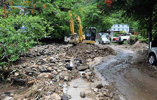
Residents are being urged to stay home while responders clear roads after the worst flooding in recent memory hit the territory on Monday night and Tuesday morning.

In some areas, including Huntums Ghut and McNamara, the floodwaters were so deep and powerful that they washed cars down the road.
The deluge, which was accompanied by intense lightning, severely damaged several roadways, and much of the Virgin Islands lost power and electricity.
The BVI Electricity Corporation had restored current to several areas as of 3 p.m. Tuesday, according to DDM, but the Water and Sewerage Department advised that the water distribution network had sustained severe damage during the storm.
“Some of the pipework has been damaged and some has been badly exposed or undermined,” DDM stated on Facebook at about 1:30 p.m. Tuesday. “Affected areas include those customers who receive water from the Sabbath Hill and Fort Hill reservoirs. It should be noted that there is also no distribution in the eastern and western end of Tortola.”
The heavy rains, which started shortly before 1 p.m. on Monday, caused the postponement of the annual August Monday Parade, which was rescheduled for noon on Saturday.
In spite of the postponement, at least three troupes marched anyway, dancing in the rain as spectators cheered from underneath tents and overhangs along Waterfront Drive.
The magnitude of the storm was unexpected, although DDM released a statement about the weather system on Monday morning.
“A weak tropical wave will generate unstable weather conditions across the islands today and tonight,” DDM stated on Facebook at 8:24 a.m. Monday. “Conditions today could be partly cloudy with scattered showers with a chance of isolated thunderstorms developing.”
It wasn’t until after 4:30 p.m. Monday, however, that the DDM’s Facebook page announced a flash flood watch, which was upgraded to a warning less than an hour later.
Shortly before noon on Tuesday, DDM announced that the National Emergency Operations Centre had been activated, and the flash flood warning was lifted about two hours later.
{fcomment}